LAYA – GASA
TREK

NTB Treks and Expeditions will welcome you at the Paro Airport. Paro sits in a beautiful valley and introduces you to this charming kingdom. Your tour guide will meet you and take you to your hotel. In the afternoon, we will visit the impressive Paro Rinpung Dzong, one of the finest examples of Bhutanese architecture. You will see the 7th-century Kyichu Lhakhang, a temple of historical significance and one of the most sacred shrines in Bhutan.
Overnight in Paro.
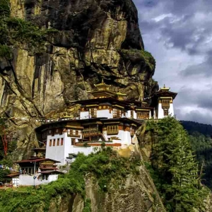
Take a day walk to the ‘Tiger’s Nest’, the sacred Taktshang monastery, which clings to the rock face 900 meters above the valley floor. Guru Rinpoche is said to have flown to the site, riding on a tigress. He subsequently edited there for three months.
It is one of Bhutan’s most holy sites and draws pilgrims from Bhutan and neighboring Buddhist countries. You can have lunch at the Taktshang cafeteria from where you get a spectacular view of the monastery. If there is any time left for sightseeing after your hike, your guide will suggest something for you to see.
Overnight in Paro.
Note: Laya Gasa trek route: originally, it was a 6-hour walk to the first day’s camp at Shana, but now a farm road has been built, and we will complete the journey in a couple of hours. In theory it is possible to drive to the end of the farm road and hike to the second day’s camp at Soi Thangthangkha all in one day, but this creates difficulties, as there is then not sufficient time to acclimatize.
Walking along the farm road is unappealing, so instead we recommend a second acclimatisation hike at Chele La near Paro, climbing high during the day to aid acclimatisation, then return to Paro.
The next morning, drive to the camp at Shana and start the hike from there giving you more time to adjust to the altitude before you climb towards base camp at Jangothang. This is our recommended approach to the start of the trek.
Today, you can do a second acclimatization hike. First, drive about an hour and a half to Chele La pass at about 3900 meters, where you will have a splendid view of the Himalayan range, weather permitting. From the road, you can walk up the incline for around 2 hours towards Gung Karpo La (4300m), continuing above the tree line along the ridge that divides the Paro and Haa valleys.
Here, if the day is clear you will see even more breathtaking views of the snowcapped mountains, including Mount Jomolhari and other further peaks such as Kanchenjunga.
Walk down the hill through rhododendron and hemlock forest towards Kila Gompa, a nunnery inhabited by about 30 nuns who live a life of contemplation and seclusion, with daily prayer and spiritual practice. The community is one of the oldest of seven nunneries.
The main temple houses ancient statues of Chenrezig and Guru Rinpoche, among others. After visiting the nunnery, you can return to the car, which takes around 15 minutes. Anything you don’t need to carry with you will be driven safely to Punakha to await your arrival.
Overnight in Paro.
Early in the morning, drive about 2 hours through the farm road to Shana, where you will start your trek. We ascend through the river valley and beautiful pine and rhododendron forests. Sadly, much of the forest has been cut to make way for electricity to be run to Jangothang and Lingshi – the sight of fallen trees is a reminder of the cost of progress.
We stop for lunch by the first bridge over the river and then continue to follow the right bank for a couple of hours until we reach a junction of two valleys, marked by a stupa. Here, we turn north towards Mount Jomolhari, which can be seen from the top of the valley. Our camp will be at 3680 meters. (19 km, 8 to 9 hours)
Overnight in camp.
The path passes a small, border army post where the valley begins to widen again, and we leave the forest behind. Enjoy views of snow-capped peaks, high mountain ridges, and yaks and yak herders. We will stop for lunch in a small hamlet where the family will welcome us. You can also stop to visit a small local school at Soe, before reaching Jangothang.
From here, it is not far to reach camp, which is in a beautiful grassy meadow beneath a ruined fortress at the base of Mount Jomolhari (4040 m). (19 km, 6 hours)
Overnight in camp.
An opportunity to explore the glacier, do some washing in the stream (icy cold!) or just take it easy. If you feel like going further afield the guide will discuss the options with you.
Overnight in camp.
The trail climbs gradually to Nyili La Pass (4680 m). Broad yak pastures can be seen along the length of the route. If the weather is clear, there is an excellent view of Lingshi Dzong as we descend into the Lingshi basin. Tserim Kang and its descending glaciers can be seen at the north end of the valley. We camp by a stone shelter at 3915 m. (18 km, 6 to 7 hours)
Overnight in camp.
This is one of the shortest trekking days. The walls are off on a path along the hillside with views across the valley. After a few hours, you will catch a splendid view of Tseri Kang before descending to Gang Yul (‘village at the pass’), a picturesque village of about 150 people.
From here it is only an hour or so on a path that runs along the hillside until we reach our camp at Chebisa (3910 m), where it is possible to visit some village houses and a waterfall just behind the village. (10 km, 5 hours)
Overnight in camp.
The trail climbs gradually at first, getting steeper and steeper through wild pastures where yaks graze. You may also catch sight of blue sheep and eagles. Eventually, we crossed Gobu La (4350 m). From here it is a short walk down through the rhododendron forest to the stream where we will stop for lunch.
The afternoon’s walk is through pine and rhododendron forests, descending to the river from where the path traverses the hillside before climbing steeply once more to reach Shomuthang (3985 m). The camp is near a tributary to the Mo Chu, which emerges below the Gasa Tsachu (Hot Spring).
Overnight in camp.
We start with a climb to Jhari La (4600 m), where we are rewarded with quite stunning views, then descend again through the forest to Tsharithang, the valley where herds of takin can normally be seen. Today’s scenery is breathtaking. Cross the river and clamber up the hillside for an hour or so to camp at Robluthang (4160 m). (18km, 7 to 8 hours). Overnight in camp.
Above camp, the yak trail, which is our path today, can be seen, taking us through a hanging valley and past a yak herder’s hut after about an hour’s walk. From here, we take the left side of the valley, and soon the Shinge La comes into view. It is a tough climb to the pass, which marks the boundary of the Laya district (4870 m).
From here the path descends rapidly through the valley to a huge bank of moraine on the edge of a lake, and behind the Kang Che Da (‘Great Tiger Mountain’) can be seen. We camp here in a meadow by the river at Limithang in the Laya district, where the locals will be seen wearing a unique regional dress (4090 m). (19 km, 8 hours).
Overnight in camp.
The path goes downhill at first through a winding river vala ley with forest of spruce and juniper. We climb gradually from the river until we enter the eastern end of Laya village (3820 m). (10 km, 5 to 6 hours). Overnight in camp.
Today allows an opportunity to explore the culture and traditions of the Laya community. It is possible to visit village houses and meet the friendly local people who will be pleased to offer you some yak butter tea. Women of Laya wear special dresses and bamboo hats, both of which are decorated with turquoise and silver ornaments.
Overnight in camp.
The trail follows the river valley and there is a breathtaking view of vibrant rivers, feeder streams, and waterfalls. At Tongchu Ja, there is a space nearby the river where you will camp for the night. (3510 m, 16 km) OR Please note that the farm road is newly built and is still under construction so we don’t know exactly how far it will have reached by the time you arrive from your trek. If there is time you can go as far as Gasa Springs to camp tonight.
You will return from the car. If you have time you can visit Gasa Dzong and the small town and then continue about 15 minutes’ drive to Gasa Hot Spring or Tsachu for the night. The spring is believed to be effective in curing various ailments, including aching joints, and many Bhutanese families visit every winter. There are eight pools, with temperatures ranging from warm to hot.
Overnight in caOR in Gasa.
After breakfast, if you wish you can have a bath again in the hot spring and then drive past rolling hillsides with vistas of fields, villages, and oak and pine forests to reach the old capital, Punakha, at 1250 meters. On the way you might like to hike an hour or so up to Khamsum Yuelley Namgyel Chorten, high on the hill across the other side of the valley. From the top, you will see a beautiful view of the valley and surrounding villages. Overnight in Punakha.
DAY 16: Drive to Thimphu/ Sightseeing
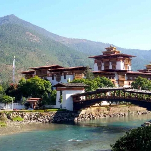
This morning, you can visit the imposing Punakha Dzong, “Palace of Great Happiness”. Built in 1637, it is strategically placed at the confluence of two rivers, the Po Chu and the Mo Chu. Then return to Thimphu over the Dochu La pass at 3050 meters. Late, we may drive up to the Radio Tower (offering splendid views of the city from a hilltop festooned with prayer and flags) and the Takin Reserve, where we can see the unique national animal, the Takin. Overnight in Thimphu.
We will visit the revered Memorial Chorten, the National Library, and the School of Traditional Arts. You could visit Changangkha temple, perched on the hill top overlooking the town. Devotees flock throughout the day to circumambulate and turn the prayer wheels.
The temple also contains beautiful wall paintings and hundreds of religious scriptures written in gold. In the afternoon, you can take in more of the sights and culture of the capital, perhaps browse the striking collection of intricate textiles at the National Textile Museum, or visit the Folk Heritage Museum.
You may also like to visit the newly opened postal museum, detailing the history of Bhutan’s postal system and showcasing Bhutan’s rich assortment of interesting stamps. Overnight in Thimphu.
Early in the morning, your guide will accompany you to the airport to see you off to your flight and wish you Tashi Delek (goodbye and good luck).
Tour Map

 Ganden to Samye Tibet Trek
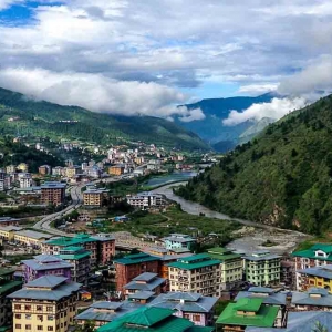
Reviews
There are no reviews yet.