Ganden to Samye
Tibet Trek

This is the first day that you enter Tibet. Your guide from NTB Treks and Expeditions will greet you at the airport or railway station and transfer you to the lovely hotel. It usually takes around 1.5 hours to drive from Lhasa Airport to downtown Lhasa and about 20 minutes from Lhasa Railway Station. Tourists could have a look at Yarlung Tsangpo River, the largest and longest river in Tibet, on their way to the hotel. After check-in, you can have a good rest first. And if you feel like going out, you can wander around the city. But just remember that you shouldn’t take too much stuff, try to go with a light pack. Meanwhile, drink some more water. It’s really useful to get acclimatized to the high altitude. Stay overnight in Lhasa.
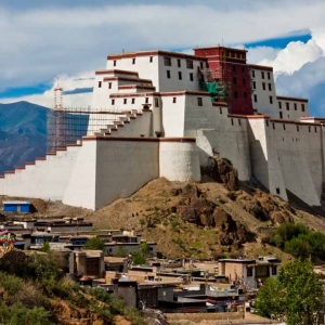
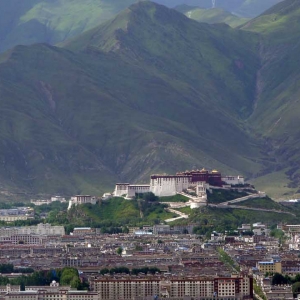
In the morning our guide will meet you at the hotel and first take you to visit the famous Potala Palace, the cardinal landmark of Tibet and the masterpiece of Tibetan architecture, it was first built by 33rd King Songtsen Gangpo in the 7th century and rebuilt later in the 17th century by 5th Dalai Lama, now it is a museum and world heritage site.
In the afternoon, we will go to visit Jokhang Temple in the center of the old Lhasa city. Jokhang Temple is one of the most sacred temples in all of Tibet, and it has always been bustling with earnest local pilgrims since the early days. After that you will take a walk around the Barkhor street which is the one of the most devotional circuit as well as a crowded central market of Lhasa, Barkhor Street is located in the old area of Lhasa City Tibet.
Drive from Lhasa to Ganden Monastery, which is about 50km northeast of Lhasa. En-route, we will also visit the less-known-by-tourists Drak Yerpa hermitage, abt 16km northeast of Lhasa. Overnight
This trek begins from the car park at the base of Ganden Monastery. Leave the car park and look for the well-trodden trail heading south along the side of Angkor Ri, the highest point on the Ganden kora. After 20 minutes, the kora branches off to the right; keep ascending to the south for another 30 minutes. You quickly lose sight of Ganden but gain views of Samadro village below you, before reaching a saddle, marked by a lapse (Carin) 2m tall and 3m in diameter.
From the saddle, look south to see the approach to the Shuga-la in the distance. Traversing the west side of the ridge from the saddle, you briefly get views of Trubshi village below and the Kyi-chu Valley to the west. After 45 minutes, the trail descends towards Hepu village.
1hr from Hepu, you reach Ani Pagong, a narrow, craggy bottleneck in the valley. Across the valley is the seasonal herders’ camp of Choden. From Ani Pagong, the trail steadily climbs for 1hr through marshy meadows to Yama Do(4490m), which offers extensive campsites. Overnight
Abv Yama Do the valley’s watercourse splits into three branches. Follow the central branch. The route leaves the flank of the valley and follows the valley bottom. The trail becomes indistinct, but it’s a straight shot up to the pass.1hr pass Yama Do leave the valley floor and ascend a shelf on the east side of the valley to avoid a steep gully that forms around the stream.
Remain on the east side of the valley as it bends on the left. You have to negotiate boulders and lumpy ground along the final steep climb to the pass. The Shuga-la(5250m) cannot be seen until you’re virtually on top of it. It’s marked by a large cairn covered in prayer flags and yak horns and is the highest point of the trek.
The trail gradually descends to the valley floor, 1.5 hours from the pass and 200m below it. The views of the valley and the lake at its head are some of the highlights of the trek. Cross the large Tsotup-chu(4980m), which flows through the valley.
From the Tsotup-chu ford, the main watercourse flows from the southeast, and a minor tributary enters from the southwest. Follow this tributary steeply up for abt 30mins until you reach a large basin and a cairn that offers fine views down onto Palang Tsodu Lake. Stay on the west side of the basin and turn into the first side valley opening on the right. A couple of minutes into the valley, you’ll pass a large group campsite.
The Chitu-la(5225m) is topped by several cairns and a small glacier tarn. Move to the west side of the pass to find the trail down and to circumvent a sheer rock wall on its south flank. A short descent will bring you into a basin with three small lakes. The trail skirts the west side of the first lake and then crosses to the eastern shores of the second two. It takes 45 minutes to reach the south end of the basin. Drop down from the basin on the west side of the stream, and in 30 minutes, you’ll pass a collection of cairns to the right.
Below the herder’s highest camp, the valley is squeezed in by vertical rock walls, forcing you to pick your way through the rock-strewn valley floor. Pass a side stream after 15 minutes and then cross over to the west side of the widening valley to recover the trail. In 20 more minutes, you will come to a flat and a seasonal Herder’s Camp on the east side of the valley, which is good for camping.
The trail is now wide and easy to follow as it traces a course down the east side of the valley. Walk through the thickening scrub forest for 1hr, and you will come to another stream entering from the east side of the main valley. Look for the wood-and-stone Diwaka Zampa Bridge(4335m) 50m abv the confluence. The valley now bends to the right, and the trail enters the thickest and tallest part of the scrub forest.
The next two-hour stretch of the trail is among the most delightful of the entire trek. According to local woodcutters, more than 15 types of trees and shrubs are found here, some growing to as high as 6m. Fragrant junipers grow on exposed south-facing slopes, while rhododendrons prefer the shadier slopes. The rhododendrons start to bloom in early May, and by the end of the month, the forest is ablaze with pink and white blossoms.
The trail winds through a series of meadows. After 40 minutes, the stony floodplain of a tributary joins the river from the north. In another 30 minutes, look for a mass of prayer flags and an ancient juniper tree at a place known as Gen Do. This is a shrine to the protector of the area, the goddess Dorje Yudronma. Just pass the shrine and cross a small tributary stream. In 1hr the forest rapidly thins, and Changtang, the first permanent village since Hepu, pops up.
Look south to the distant mountains; this is the range on the far side of the Yarlung Tsangpo Valley. 45 minutes down the valley at a prominent bend in the valley is the turn-off for the Yamalung Hermitage, visible on the cliff face high above the valley.
From the turn-off to Yamalung the walking trail is a full-fledged motorable road and the valley much wider. In 15mins, you will reach a bridge; the road now sticks to the west side of the valley all the way to Samye, a 3.5hr walk. 20mins from the bridge you will come to the village of Nyango with its substantially built stone houses. A big tributary stream, entering from the northwest, joins the Samye Valley here.
30mins’ walk past Nyango is the village of Wango and, 1hr beyond it, the hamlet of Pisha. From the lower end of Pisha, a hill can be seen in the middle of the mouth of the Samye Valley. This is Hepo Ri, one of Tibet’s most sacred mountains. The entire lower Samye Valley—a tapestry of fields, woods, and villages—can be seen from Pisha.
15mins past Pisha a ridge spur called Dragmar meets the trail. On the ridge is the partially rebuilt palace where King Trisong Detsen is said to have been born. Formerly a lavish temple, it now stands empty.
20mins further down the trail is Sangbu village, from where there are good views of the golden spires of Samye. The route follows the 4WD track directly to Samye along the Margin of woods and desert: it takes abt 1hr. You finally enter the perimeter wall of Samye, abt 3hrs from Nyango. Overnight
Your tour ends today. Our guide and driver will collect you from your hotel to transfer to Lhasa Airport/Railway Station for your next destination.
Tour Map

 Shalu to Nartang Trek
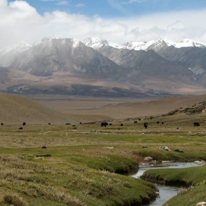
Reviews
There are no reviews yet.